Shire Statistics
General
- The Wongan Hills townsite is located 184 kilometres north-east of Perth, elevation 286 metres (938 feet).
- Ballidu townsite is located 219 kilometres north-east of Perth and directly north of Wongan Hills, elevation 304.8 metres (1000 feet).
- The map coordinates for Wongan Hills are Lat 30 0 54 min South and Long 116 0 43 min East.
- The Shire contains 406 kilometres of sealed roads and 873 kilometres of unsealed roads.
- There are over 641 hectares of parks and gardens and 736 dwellings.
Population
 The approximate population is relatively stable. In the Central Wheatbelt the trend in recent years has been a decrease in numbers, characteristic of the majority of country towns. This has been due to the use of larger machinery increasing the size of land holdings.
However, with the development of agricultural supporting industries and service industries in country towns, there is now movement back to the regional centres. The need to be in touch with a market place has meant many industries and their employees have moved back to the country regions.
The ‘country way-of-life' is attracting many families back to the countryside, as they have the benefits of the city centres and the advantages of country living.

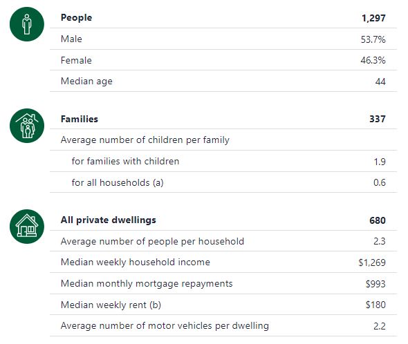
In the 2021 Census, there were 1,297 people in Wongan-Ballidu.
For more information and statistics please visit: 2021 Wongan-Ballidu, Census All persons QuickStats | Australian Bureau of Statistics (abs.gov.au)