Shire Statistics
General
- The Wongan Hills townsite is located 184 kilometres north-east of Perth, elevation 286 metres (938 feet).
- Ballidu townsite is located 219 kilometres north-east of Perth and directly north of Wongan Hills, elevation 304.8 metres (1000 feet).
- The map coordinates for Wongan Hills are Lat 30 0 54 min South and Long 116 0 43 min East.
- The Shire contains 406 kilometres of sealed roads and 873 kilometres of unsealed roads.
- There are over 641 hectares of parks and gardens and 736 dwellings.
For more detailed information please go to:
www.id.com.au
Population
The approximate population is relatively stable. In the Central Wheatbelt the trend in recent years has been a decrease in numbers, characteristic of the majority of country towns. This has been due to the use of larger machinery increasing the size of land holdings.
However, with the development of agricultural supporting industries and service industries in country towns, there is now movement back to the regional centres. The need to be in touch with a market place has meant many industries and their employees have moved back to the country regions.
The ‘country way-of-life' is attracting many families back to the countryside, as they have the benefits of the city centres and the advantages of country living.
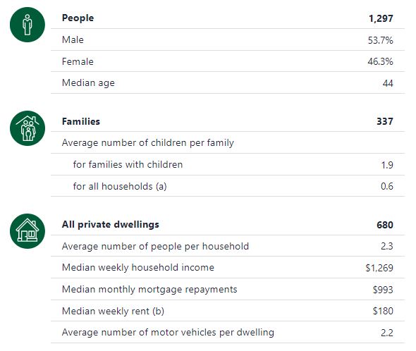
Estimated Resident Population at 30th June. Courtesy of Australian Bureau of Statistics 30th June
Population by Sex | 2004 | 2005 | 2006 | 2007 | 2008 |
Male |
812 |
793 |
772 |
748 |
753 |
Female |
716 |
711 |
701 |
693 |
687 |
Persons |
1,528 |
1,504 |
1,473 |
1,441 |
1,440 |
Population by Age Groups | | | | | |
0 - 15 years |
24.1% |
23.2% |
23.1% |
22.3% |
21.5% |
15 - 24 years |
8.6% |
9% |
9% |
9% |
9.1% |
25 - 34 years |
14.1% |
13.2% |
13.2% |
12.9% |
13.5% |
35 - 44 years |
18.3% |
18.1% |
17.1% |
17.3% |
16% |
45 - 54 years |
16% |
16.6% |
16.8% |
16.8% |
17.4% |
55 - 64 years |
9.5% |
9.6% |
10.4% |
11.1% |
11.9% |
65 - 74 years |
4.8% |
5.1% |
5.4% |
4.9% |
5.2% |
75 - 84 years |
3.5% |
4.3% |
4.3% |
3.9% |
3.5% |
85 years and over |
1% |
0.8% |
1.3% |
1.9% |
1.9% |
Labour Market
The labour force within the Shire of Wongan-Ballidu is relatively stable and the majority of people are employed in the agricultural Industry or supporting industries. Wongan-Ballidu has a small percentage of unemployed people.
The unemployment rate for the Shire of Wongan Ballidu in the June 2003 quarter was 1.9% compared to 5.6% for regional WA and 5.9% for the state.
Employment Sectors of the Wongan-Ballidu Region
Courtesy of Australian Bureau of Statistics 1996
Employment Sector | Amount | % of Workforce |
Agriculture |
321 |
39.6% |
Wholesale and Retail Trade |
151 |
18.6% |
Accommodation, Cafes and Restaurants |
21 |
2.6% |
Manufacturing |
56 |
6.9% |
Industry not stated |
10 |
1.2% |
Finance, Property and Business Service |
44 |
5.4% |
Government and Administrations Defence |
32 |
4.0% |
Transport and Storage |
37 |
4.6% |
Education |
50 |
6.2% |
Construction |
19 |
2.3% |
Electricity, Gas and Water |
3 |
0.4% |
Communication Services |
3 |
0.4% |
Industry not Classifiable |
9 |
1.1% |
Personal and Other Services |
12 |
1.5% |
Health and Community Services |
39 |
4.8% |
Cultural and Recreational Services |
3 |
0.4% |
Totals |
810 |
100% |
Economic
The Shire of Wongan-Ballidu is renowned for its grain production. The States total production for the 1995 season was approximately 12.5 million tonnes of which the Wongan-Ballidu region contributed over 3%.
In 1999/00 the Shire of Wongan Ballidu's total Agricultural production was valued at $90.7 million, which was a 41.8% growth. The Shire of Wongan-Ballidu currently contributes 1.8% of the States total agricultural production by value.